


介绍 PhoneMaps
Mobile phone app PhoneMaps offers FOR FREE zoomable hiking and cycling maps with full network of marked hiking and cycling routes of almost whole Europe. In app you can plan your holiday, during the activity orientate in terrain and record your tracks and experiences and then share them with your friends. Hiking or cycling content with marked hiking/cycling routes you will not find in general map applications in your phone, you will not need to go to bookshop and buy paper map.
- Language: English, German, Czech, Slovak, Polish, Italian, Chinese
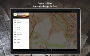
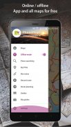
- Online and offline maps
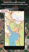
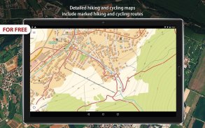
- Detailed hiking and cycling maps include marked hiking and cycling routes
- Maps created by cartographic companies freytag&berndt and SHOCart
- Hiking and travel guides from Bergverlag Rother, freytag&berndt
- Vector maps: smaller, can be easily zoomable and rotated
- Download map of area where you will go, map tiles are displayed as one map
- All points in maps with interactive information (address, website, email, timetable, ....)
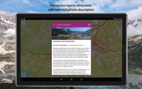
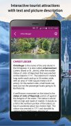
- Interactive tourist attractions in maps (photos and texts)
- Current GPS position
- Locality searching
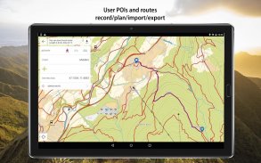
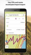
- Record/import/export/management of user routes (gpx)
- Record user Points of interest
- Spatially localized taking photos in app
- Online routing and searching of optimal routes in a map (for hikers, cyclers, cars)
- Statistics of routes + elevation models of routes
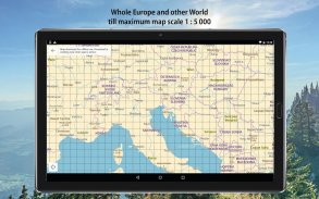
- Hiking / cycling map till 1:5 000 - Andorra, Austria, Belgium, Bulgaria, Croatia, Czech Republic, Denmark, Estonia, Finland, France, Germany, Greece, Ireland, Israel, Italy, Hungary, Latvia, Lichtenstein, Lithuania, Luxembourg, Monaco, Montenegro, Netherlands, Norway, Poland, Romania, San Marino, Spain, Slovakia, Slovenia, Sweden, Switzerland, United Kingdom, USA, Nepal, Japan, Taiwan, New Zealand, Israel, Kilimanjaro
- Topographic map 1:5 000 - rest of the world
AND THE BEST THING IS THAT APP AND ALL MAPS AND FUNCTIONS IN APP ARE FOR FREE!
手机应用程序PhoneMaps提供免费的可缩放远足和自行车地图,以及几乎整个欧洲的标记远足和自行车路线的完整网络。在应用程序中,您可以计划您的假期,在活动期间定位地形并记录您的曲目和体验,然后与您的朋友分享。徒步或骑自行车的内容与标记远足/自行车路线,你将无法在手机的一般地图应用程序中找到,你不需要去书店和购买纸质地图。
- 语言:英语,德语,捷克语,斯洛伐克语,波兰语,意大利语,中文
- 在线和离线地图
- 详细的远足和骑自行车地图包括标记远足和自行车路线
- 由制图公司freytag&berndt和SHOCart创建的地图
- Bergverlag Rother,freytag&berndt的徒步旅行和旅行指南
- 矢量地图:较小,可以轻松缩放和旋转
- 下载您要去的地区的地图,地图图块显示为一个地图
- 地图中包含互动信息的所有积分(地址,网站,电子邮件,时间表......)
- 地图中的互动旅游景点(照片和文字)
- 当前的GPS位置
- 地点搜索
- 记录/导入/导出/管理用户路线(gpx)
- 记录用户兴趣点
- 在应用程序中空间本地化拍照
- 在线路由和在地图中搜索最佳路线(适用于徒步旅行者,骑自行车者,汽车)
- 路线统计+路线高程模型
- 远足/骑自行车地图直到1:5 000 - 安道尔,奥地利,比利时,保加利亚,克罗地亚,捷克共和国,丹麦,爱沙尼亚,芬兰,法国,德国,希腊,爱尔兰,以色列,意大利,匈牙利,拉脱维亚,利希滕斯坦,立陶宛,卢森堡,摩纳哥,黑山,荷兰,挪威,波兰,罗马尼亚,圣马力诺,西班牙,斯洛伐克,斯洛文尼亚,瑞典,瑞士,英国,美国,尼泊尔,日本,台湾,新西兰,以色列,乞力马扎罗
- 地形图1:5 000 - 世界其他地方
最好的事情是应用程序和应用程序中的所有地图和功能是免费的!
PhoneMaps - 版本99.0
(14-04-2020)PhoneMaps - APK信息
APK版本: 99.0程序包: eu.phonemaps同类应用
您可能还会喜欢……


